153 countries
(and areas)
 - Azerbaijan
- Bahrain
- Barbados
- Belgium
- Belize
- Benin
- Bhutan
- Bolivia
- Bonaire
- Bosnia and Herzegovina
- Botswana
- Brazil
- British Virgin Islands
- Brunei
- Bulgaria
- Cambodia
- Canada
- Cape Verde
- Chile
- China
- Costa Rica
- Croatia
- Cuba
- Curacao
- Cyprus
- Czech Republic
- Denmark
- Dominica
- Dominican Republic
- Egypt
- El Salvador
- England
- Estonia
- Eswatini (Swaziland)
- Ethiopia
- Fiji
- Finland
- France
- French Guiana
- Georgia
- Germany
- Gibraltar
- Greece
- Grenada
- Guadeloupe
- Guatemala
- Honduras
- Hong Kong
- Hungary
- Iceland
- India
- Indonesia
- Iran
- Ireland
- Israel
- Italy
- Jamaica
- Japan
- Jordan
- Kazakhstan
- Kenya
- Kosovo
- Kuwait
- Kyrgyzstan
- Laos
- Latvia
- Lebanon
- Lesotho
- Liechtenstein
- Lithuania
- Luxembourg
- Macau
- Madagascar
- Malawi
- Malaysia
- Maldives
- Malta
- Martinique
- Mexico
- Moldova
- Monaco
- Mongolia
- Montenegro
- Morocco
- Mozambique
- Namibia
- Nepal
- Netherlands
- New Zealand
- Nicaragua
- North Macedonia
- Northern Ireland
- Norway
- Oman
- Pakistan
- Palestine
- Peru
- Philippines
- Poland
- Portugal
- Qatar
- Republic of Korea
- Romania
- Russia
- Saint Kitts and Nevis
- Saint Lucia
- Saint Martin
- Saint Vincent and the Grenadines
- San Marino
- Saudi Arabia
- Scotland
- Senegal
- Serbia
- Singapore
- Sint Maarten
- Slovakia
- Slovenia
- South Africa
- Spain
- Sri Lanka
- Suriname
- Sweden
- Switzerland
- Tajikistan
- Tanzania
- Thailand
- The Gambia
- Tibet
- Togo
- Transnistria
- Trinidad and Tobago
- Tunisia
- Turkey
- Turkmenistan
- Uganda
- United Arab Emirates
- United States
- Uruguay
- Uzbekistan
- Vatican City
- Vietnam
- Wales
- Zambia
- Zanzibar
- Azerbaijan
- Bahrain
- Barbados
- Belgium
- Belize
- Benin
- Bhutan
- Bolivia
- Bonaire
- Bosnia and Herzegovina
- Botswana
- Brazil
- British Virgin Islands
- Brunei
- Bulgaria
- Cambodia
- Canada
- Cape Verde
- Chile
- China
- Costa Rica
- Croatia
- Cuba
- Curacao
- Cyprus
- Czech Republic
- Denmark
- Dominica
- Dominican Republic
- Egypt
- El Salvador
- England
- Estonia
- Eswatini (Swaziland)
- Ethiopia
- Fiji
- Finland
- France
- French Guiana
- Georgia
- Germany
- Gibraltar
- Greece
- Grenada
- Guadeloupe
- Guatemala
- Honduras
- Hong Kong
- Hungary
- Iceland
- India
- Indonesia
- Iran
- Ireland
- Israel
- Italy
- Jamaica
- Japan
- Jordan
- Kazakhstan
- Kenya
- Kosovo
- Kuwait
- Kyrgyzstan
- Laos
- Latvia
- Lebanon
- Lesotho
- Liechtenstein
- Lithuania
- Luxembourg
- Macau
- Madagascar
- Malawi
- Malaysia
- Maldives
- Malta
- Martinique
- Mexico
- Moldova
- Monaco
- Mongolia
- Montenegro
- Morocco
- Mozambique
- Namibia
- Nepal
- Netherlands
- New Zealand
- Nicaragua
- North Macedonia
- Northern Ireland
- Norway
- Oman
- Pakistan
- Palestine
- Peru
- Philippines
- Poland
- Portugal
- Qatar
- Republic of Korea
- Romania
- Russia
- Saint Kitts and Nevis
- Saint Lucia
- Saint Martin
- Saint Vincent and the Grenadines
- San Marino
- Saudi Arabia
- Scotland
- Senegal
- Serbia
- Singapore
- Sint Maarten
- Slovakia
- Slovenia
- South Africa
- Spain
- Sri Lanka
- Suriname
- Sweden
- Switzerland
- Tajikistan
- Tanzania
- Thailand
- The Gambia
- Tibet
- Togo
- Transnistria
- Trinidad and Tobago
- Tunisia
- Turkey
- Turkmenistan
- Uganda
- United Arab Emirates
- United States
- Uruguay
- Uzbekistan
- Vatican City
- Vietnam
- Wales
- Zambia
- Zanzibar


Copyright 2004 - 2026
Veeronline.nl Travel Adventures
Home > Netherlands > Castle Weekend Vreeland > Travelogue day 2
Travelogue Castle Weekend Vreeland
November 2022 2020 (3 days)
Netherlands > The Vredelantse Wooden Shoe Path
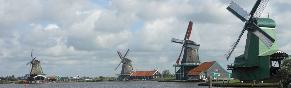
Dag 2 - Saturday 21 November 2020At half past eight, as we walk down the stairs, a full breakfast is already laid out on the table. “Did you sleep well?” Monique, the owner, asks kindly. The breakfast gives us a good start for our walks through the surroundings. We have decided to do two walks today: one in the morning and one in the afternoon. Since no restaurants are open, it’s convenient to have lunch at our own place and use the bathroom there. Around half past nine, we set off for the Vredelantsepad. The route runs right past our house, so it’s easy to pick it up here. Via Voorstraat we reach the Boerenlaantje, a walking path through the trees. At Raadhuisstraat, we cross over to Sperwerveld. In this meadow, the Vredelant Castle once stood in the 13th century. The castle was built by order of the bishop of Utrecht on the border between the bishopric of Utrecht and the County of Holland. Utrecht wanted to prevent toll collection on the Vecht River by building it. In the 16th century, the castle fell into disrepair and was demolished. Only the foundation remains under the grass. Via the Jubileumlaantje, we come to the church. Along the Vecht River, we follow a towpath behind the houses. It feels like we are walking on private property. The path ends at the drawbridge, which we drove over yesterday; now we cross it on foot. We turn right and follow the bends of the Vecht. First, we come to the Ruiter mill, which dates back to 1789. After a fire in 1910, the grain mill was restored. Volunteers still operate the mill. Normally, it is open to visitors on Saturdays, but due to COVID restrictions, that is not possible now.
We continue our route. On the left are meadows with occasional farms. This Dorssewaardpolder used to be part of the Welgelegen estate. In the 18th century, a vast landscaped park was created around the estate. On the right are houseboats along the Vecht. On the opposite bank, we see several country houses. What a beautiful area. We pass the Nes, a body of water in a bend of the river. Due to sand extraction, the island has gradually been swallowed by the river. Only small islets mark the edges of the former island. There is no recreation on the water today; it is freezing cold and drizzling occasionally. At the farm ‘De Willigen,’ the route turns left. The clogs trail markers point to a farmyard. Is this really the way? We cautiously walk onto the yard. The farmer on his tractor doesn’t even look up — clearly used to this. Behind the stables, the route continues. A half-paved path runs between the meadows. Some parts are quite muddy and wet. We carefully walk along the edges. Where the paved path turns, the route goes left. Via stepping stones, we enter a patch of bushes and then walk over marshy meadows. It is impossible to keep our shoes and pants clean. But who cares? We pass several gates and small bridges. Eventually, we reach the Amsterdam-Rhine Canal.

Several ships sail along this wide waterway. We follow the bike path southward. What a difference from the marshy meadow! Traffic rushes past at high speed. Officially, the route leads back to Vreeland from here. We decide to walk a little further along the canal. We pass under the highway bridge toward the hamlet of Kerklaan. Here, we turn toward Loenen aan de Vecht. Like Vreeland, Loenen has an old center. Due to its location near the Loosdrechtse Plassen lakes, it attracts many tourists in summer. At the Vecht River, we turn back toward Vreeland — a stretch of a little over three kilometers along the river. The last section follows a narrow path along houseboats. Without directions, we would never have found this path ourselves. It feels private. Around one o’clock, we return to Vreeland. We have walked about fifteen kilometers.

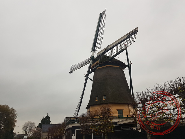
In our own little kitchen, we prepare a nice lunch and have a cup of coffee. In the afternoon, we walk eastward for a loop around the Wijde Blik, the northernmost lake of the Loosdrechtse Plassen. The weather has not improved — it’s gray and drizzling — but this does not stop us from our walk. We follow Vreelandseweg, a road between meadows and water. On the left are polders; on the right, we have a view of the Wijde Blik. These lakes were formed by peat extraction. Sometimes the water is as deep as thirty meters. The wind always causes currents in the water, so the Wijde Blik practically never freezes. Many species of birds and ducks have chosen this area as their home. We pass the Gabriël mill. This mill used to keep the polder dry. The two other mills have been lost. At the ‘Kijkuit’ bunker, we follow the provincial road along an embankment via a footpath. We pass recreation areas and marinas. Eventually, we reach Kortenhoef. Here we turn toward Loosdrecht. This road along the ‘het Hol’ nature reserve has no sidewalks. We walk single file on the left side of the road. There is a lot of traffic on this narrow road. In this dull weather, we watch carefully to see if oncoming cars see us. We don’t have much space because on our left there is a ditch. Along this road are several ‘Vervenershuisjes’ — extremely small workers’ houses of the peat diggers. These tiny houses sharply contrast with the luxurious villas also along this road. At a bend in the road, we turn right onto an unpaved path on a dike between the lakes. What a beautiful path to walk. Water is on both sides, and ahead of us is a kilometers-long dike barely ten meters wide, covered with trees.

It amazes me that this dike withstands the power of the water’s forces. On the other side of the path, we come back into Vreeland. It is just after four o’clock, but it feels as if evening has already fallen. Quickly, we return to our accommodation, pour ourselves a drink, and close the curtains. Today, we have walked more than twenty-five kilometers. Unfortunately, we have to go out again. Tonight, we need to pick up our food again at restaurant ‘Mevrouw Daalder’. Today we chose chicken satay, noodles, and a fresh salad. This tastes great again. In the evening, we watch a Netflix movie lying in bed.
 The castle of Count Floris V
 The garden of De Haar Castle in autumn colors
 The Muiderslot Castle in Muiden
 The Knights Hall in De Haar Castle
Travelogue Castle Weekend Vreeland
Dag 2 | Netherlands > The Vredelantse Wooden Shoe Path
Dag 3 | Netherlands > Castle De Haar