153 countries
(and areas)
 - Azerbaijan
- Bahrain
- Barbados
- Belgium
- Belize
- Benin
- Bhutan
- Bolivia
- Bonaire
- Bosnia and Herzegovina
- Botswana
- Brazil
- British Virgin Islands
- Brunei
- Bulgaria
- Cambodia
- Canada
- Cape Verde
- Chile
- China
- Costa Rica
- Croatia
- Cuba
- Curacao
- Cyprus
- Czech Republic
- Denmark
- Dominica
- Dominican Republic
- Egypt
- El Salvador
- England
- Estonia
- Eswatini (Swaziland)
- Ethiopia
- Fiji
- Finland
- France
- French Guiana
- Georgia
- Germany
- Gibraltar
- Greece
- Grenada
- Guadeloupe
- Guatemala
- Honduras
- Hong Kong
- Hungary
- Iceland
- India
- Indonesia
- Iran
- Ireland
- Israel
- Italy
- Jamaica
- Japan
- Jordan
- Kazakhstan
- Kenya
- Kosovo
- Kuwait
- Kyrgyzstan
- Laos
- Latvia
- Lebanon
- Lesotho
- Liechtenstein
- Lithuania
- Luxembourg
- Macau
- Madagascar
- Malawi
- Malaysia
- Maldives
- Malta
- Martinique
- Mexico
- Moldova
- Monaco
- Mongolia
- Montenegro
- Morocco
- Mozambique
- Namibia
- Nepal
- Netherlands
- New Zealand
- Nicaragua
- North Macedonia
- Northern Ireland
- Norway
- Oman
- Pakistan
- Palestine
- Peru
- Philippines
- Poland
- Portugal
- Qatar
- Republic of Korea
- Romania
- Russia
- Saint Kitts and Nevis
- Saint Lucia
- Saint Martin
- Saint Vincent and the Grenadines
- San Marino
- Saudi Arabia
- Scotland
- Senegal
- Serbia
- Singapore
- Sint Maarten
- Slovakia
- Slovenia
- South Africa
- Spain
- Sri Lanka
- Suriname
- Sweden
- Switzerland
- Tajikistan
- Tanzania
- Thailand
- The Gambia
- Tibet
- Togo
- Transnistria
- Trinidad and Tobago
- Tunisia
- Turkey
- Turkmenistan
- Uganda
- United Arab Emirates
- United States
- Uruguay
- Uzbekistan
- Vatican City
- Vietnam
- Wales
- Zambia
- Zanzibar
- Azerbaijan
- Bahrain
- Barbados
- Belgium
- Belize
- Benin
- Bhutan
- Bolivia
- Bonaire
- Bosnia and Herzegovina
- Botswana
- Brazil
- British Virgin Islands
- Brunei
- Bulgaria
- Cambodia
- Canada
- Cape Verde
- Chile
- China
- Costa Rica
- Croatia
- Cuba
- Curacao
- Cyprus
- Czech Republic
- Denmark
- Dominica
- Dominican Republic
- Egypt
- El Salvador
- England
- Estonia
- Eswatini (Swaziland)
- Ethiopia
- Fiji
- Finland
- France
- French Guiana
- Georgia
- Germany
- Gibraltar
- Greece
- Grenada
- Guadeloupe
- Guatemala
- Honduras
- Hong Kong
- Hungary
- Iceland
- India
- Indonesia
- Iran
- Ireland
- Israel
- Italy
- Jamaica
- Japan
- Jordan
- Kazakhstan
- Kenya
- Kosovo
- Kuwait
- Kyrgyzstan
- Laos
- Latvia
- Lebanon
- Lesotho
- Liechtenstein
- Lithuania
- Luxembourg
- Macau
- Madagascar
- Malawi
- Malaysia
- Maldives
- Malta
- Martinique
- Mexico
- Moldova
- Monaco
- Mongolia
- Montenegro
- Morocco
- Mozambique
- Namibia
- Nepal
- Netherlands
- New Zealand
- Nicaragua
- North Macedonia
- Northern Ireland
- Norway
- Oman
- Pakistan
- Palestine
- Peru
- Philippines
- Poland
- Portugal
- Qatar
- Republic of Korea
- Romania
- Russia
- Saint Kitts and Nevis
- Saint Lucia
- Saint Martin
- Saint Vincent and the Grenadines
- San Marino
- Saudi Arabia
- Scotland
- Senegal
- Serbia
- Singapore
- Sint Maarten
- Slovakia
- Slovenia
- South Africa
- Spain
- Sri Lanka
- Suriname
- Sweden
- Switzerland
- Tajikistan
- Tanzania
- Thailand
- The Gambia
- Tibet
- Togo
- Transnistria
- Trinidad and Tobago
- Tunisia
- Turkey
- Turkmenistan
- Uganda
- United Arab Emirates
- United States
- Uruguay
- Uzbekistan
- Vatican City
- Vietnam
- Wales
- Zambia
- Zanzibar


Copyright 2004 - 2026
Veeronline.nl Travel Adventures
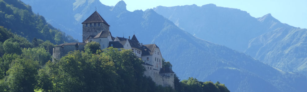
Home > Liechtenstein > Road Trip Germany and Switzerland > Travelogue day 5
Travelogue Road Trip Germany and Switzerland
August 1530 2020 (16 days)
Liechtenstein > Fürstensteig Mountain Hike
Dag 5 - Wednesday 19 August 2020What would breakfast look like in a self-check-in hotel? We follow the route to the breakfast room. Breakfast is served in the other building. A buffet is set up where everyone can assemble their own breakfast. The milk, orange juice, and cold cuts are kept in refrigerated drawers. For coffee, there is a machine. The service is minimal, but everything is available. After finishing, you are asked to clear your tray so the table becomes available for the next guests. A fine solution. Fortunately, someone still comes to clean the tables. I have a hearty breakfast. Today we are going to do a substantial mountain hike over the Fürstensteig and the ridges of the Drei Schwestern (Three Sisters). Yesterday, the staff member at the Tourist Info emphasized that it is a tough hike and only for experienced walkers.

You absolutely must not have a fear of heights or dizziness, she stressed. On the narrow mountain paths, you could slip and fall hundreds of meters down. With these warnings in mind, we take the bus from our hotel. According to the bus company’s website, a day pass is the most economical. The driver sees problems with the number of zones and advises just to buy a ticket to Gaflei, the starting point of the Fürstensteig hike. On the bus, everyone wears hiking boots. Probably everyone is going hiking in the mountains. At Triesenberg Post, everyone gets off to quickly change to line 22. This bus specifically waited for the slightly delayed bus we were on. Through hairpin bends, we quickly gain altitude. In about twenty minutes, we reach the end of the bus line: Gaflei. Here the hike begins. A clear sign indicates the route, but also shows a time estimate of 5 hours and 45 minutes. We had assumed a maximum of five hours walking. All the more reason to get going quickly. The path immediately climbs steeply. The village behind us quickly shrinks smaller and smaller. When we get above the trees, near the steep bare rocks, the path also becomes rougher. We step from rock to rock, avoiding loose gravel. Hundreds of meters below in the valley, we see Liechtenstein, the Swiss mountain slopes, and the Rhine that separates the two countries. What a magnificent sight. On the narrow and difficult sections, steel cables are fixed to the rocks, giving extra grip. The path is barely a meter wide. Next to the path, it sometimes drops hundreds of meters. The warning we received was no exaggeration. After about an hour, we reach the top of the Fürstensteig. Here we look down into both valleys: Liechtenstein and Switzerland to the left, and the rolling Austrian hills to the right. A herd of cows and the sound of alpine bells complete the picture. At this point, we have a choice. We can circle the mountain back to Gaflei or continue along the ridge of the Drei Schwestern towards the mountain village of Planken. We choose the latter, heavier option. From the Fürstensteig, we see the narrow path against the mountainside. We head for the next goal, the top of the Gafleispitz. Via the narrow path along the mountainside, we climb higher and higher. The weather is nice today for hiking. The sun is shining and it’s dry. A veil of clouds occasionally dims the sun. Perfect hiking weather. At the top of the Kuegrat stands a large cross. Via steel cables, we climb the last bit to the summit. We’ve been walking for about two hours.

After a short descent, we start the climb to the Garsellikopf, the next peak. The view remains fabulously beautiful. Rightly, this hike is called the most beautiful mountain hike in Liechtenstein. As we climb again, the rocks become more rugged and the path steeper. The last section requires literally climbing with hands and feet. In some places, steel cables help. We stay just below the mountain top. A Swiss couple comes down the other side. Especially the woman is out of breath. She warns that the Drei Schwestern are tough to climb. Would that be harder than the section we just scrambled up? The route is beautiful, but we don’t want it to be any harder than this. We descend a bit and find a spot on the ridge for lunch. We brought bread and cheese. With views on both sides of the mountain range, we enjoy our lunch. In the distance, sheep graze on the slopes. The sign indicates it’s still one hour’s walk to the top of the Drei Schwestern from here. That’s actually longer than we expected. We had seen the three peaks ahead for some time. Estimating distance in the mountains is tricky. The rock formations are so immense. Until just before the sisters, the route rises gradually. This part is manageable. Only near the last peak of our route does the path steepen considerably. We climb and scramble over rocks. Sometimes holes are made to place your feet. Elsewhere, iron hooks are hammered into the rocks to help climbing. Around half past two, we proudly stand on the summit of the Drei Schwestern peak. A family from Liechtenstein points out the other two sisters, which lie just a bit lower. From here, the route only goes downhill, they assure us. We’ve been walking for four and a half hours. We’re ready for the final descent. The descent goes quickly. Using steel cables, we lower ourselves while our feet search for suitable rocks for grip. In some places, steps are cut into the rocks, wooden beams are hung for support, and two steel ladders are installed at very steep spots. We descend further. In the valley below, we see the green alpine meadows and also the Gafadura Hut. Could that be the endpoint? A slight disappointment grips us when we see a sign to Planken at the alpine meadow.

It’s still an hour and a half walk. This means we took longer on the hike than indicated. We had hoped to catch the 3:45 pm bus in Planken. We won’t make it. Probably not the next bus, one hour later, either. There is no choice but to continue the descent to Planken. After half an hour, we reach the Gafadura Hut. A mountain hut with hospitality. The descent to Planken is still well over an hour. We decide to have a drink here. From this point, a gravel road zigzags downwards. The hiking trail cuts some corners. The path is steep and slippery in the mountain shadows. We’ve been hiking for over six hours, and fatigue is setting in. We decide to continue along the road. It may be longer, but it’s easier walking. At a quarter past five, we enter Planken. Much later than we had expected. At the bus stop, we sit on a bench. The bus only comes in half an hour. At quarter to six, we board the bus. In Schaan, we transfer to the bus toward Vaduz. All bus schedules are coordinated so that transfers run smoothly. Twenty minutes later, we arrive in the capital. On the promenade, we look for a cozy terrace. Quickly, we order a beer and something to eat. Finally, we still have one last bus leg. Around eight o’clock, we get off in front of our hotel. Tired but satisfied. Those are the right words. We had a fantastic hike today and the weather was perfect. Tomorrow, our muscles will probably be sore.
 Switzerland
  A side altar in the cathedral of St Gallen
 The curves of the mountain pass toward the Italian part of Switzerland
 The St Lawrence Church in St Gallen
 Germany
  The beautifully lit houses of Monschau
Travelogue Road Trip Germany and Switzerland
Dag 2 | Germany > Medieval Rothenburg
Dag 3 | Germany > Harburg and Ottobeuren
Dag 4 | Switzerland > The St. Gallen Library
Dag 5 | Liechtenstein > Fürstensteig Mountain Hike
Dag 6 | Switzerland > Around the Davos Lake
Dag 7 | Switzerland > Through the Mountains to Lucerne
Dag 8 | Switzerland > The Dying Lion
Dag 9 | Switzerland > The Oeschinen Mountain Lake
Dag 10 | Switzerland > On Top of the Gornergrat
Dag 11 | Switzerland > The Great St. Bernard Pass
Dag 12 | Switzerland > The Castle of Chillon
Dag 13 | Germany > The Basel Minster
Dag 14 | Germany > The Cologne Cathedral
Dag 15 | Germany > Historic Monschau
Dag 16 | Germany > Farewell Monschau