153 countries
(and areas)
 - Azerbaijan
- Bahrain
- Barbados
- Belgium
- Belize
- Benin
- Bhutan
- Bolivia
- Bonaire
- Bosnia and Herzegovina
- Botswana
- Brazil
- British Virgin Islands
- Brunei
- Bulgaria
- Cambodia
- Canada
- Cape Verde
- Chile
- China
- Costa Rica
- Croatia
- Cuba
- Curacao
- Cyprus
- Czech Republic
- Denmark
- Dominica
- Dominican Republic
- Egypt
- El Salvador
- England
- Estonia
- Eswatini (Swaziland)
- Ethiopia
- Fiji
- Finland
- France
- French Guiana
- Georgia
- Germany
- Gibraltar
- Greece
- Grenada
- Guadeloupe
- Guatemala
- Honduras
- Hong Kong
- Hungary
- Iceland
- India
- Indonesia
- Iran
- Ireland
- Israel
- Italy
- Jamaica
- Japan
- Jordan
- Kazakhstan
- Kenya
- Kosovo
- Kuwait
- Kyrgyzstan
- Laos
- Latvia
- Lebanon
- Lesotho
- Liechtenstein
- Lithuania
- Luxembourg
- Macau
- Madagascar
- Malawi
- Malaysia
- Maldives
- Malta
- Martinique
- Mexico
- Moldova
- Monaco
- Mongolia
- Montenegro
- Morocco
- Mozambique
- Namibia
- Nepal
- Netherlands
- New Zealand
- Nicaragua
- North Macedonia
- Northern Ireland
- Norway
- Oman
- Pakistan
- Palestine
- Peru
- Philippines
- Poland
- Portugal
- Qatar
- Republic of Korea
- Romania
- Russia
- Saint Kitts and Nevis
- Saint Lucia
- Saint Martin
- Saint Vincent and the Grenadines
- San Marino
- Saudi Arabia
- Scotland
- Senegal
- Serbia
- Singapore
- Sint Maarten
- Slovakia
- Slovenia
- South Africa
- Spain
- Sri Lanka
- Suriname
- Sweden
- Switzerland
- Tajikistan
- Tanzania
- Thailand
- The Gambia
- Tibet
- Togo
- Transnistria
- Trinidad and Tobago
- Tunisia
- Turkey
- Turkmenistan
- Uganda
- United Arab Emirates
- United States
- Uruguay
- Uzbekistan
- Vatican City
- Vietnam
- Wales
- Zambia
- Zanzibar
- Azerbaijan
- Bahrain
- Barbados
- Belgium
- Belize
- Benin
- Bhutan
- Bolivia
- Bonaire
- Bosnia and Herzegovina
- Botswana
- Brazil
- British Virgin Islands
- Brunei
- Bulgaria
- Cambodia
- Canada
- Cape Verde
- Chile
- China
- Costa Rica
- Croatia
- Cuba
- Curacao
- Cyprus
- Czech Republic
- Denmark
- Dominica
- Dominican Republic
- Egypt
- El Salvador
- England
- Estonia
- Eswatini (Swaziland)
- Ethiopia
- Fiji
- Finland
- France
- French Guiana
- Georgia
- Germany
- Gibraltar
- Greece
- Grenada
- Guadeloupe
- Guatemala
- Honduras
- Hong Kong
- Hungary
- Iceland
- India
- Indonesia
- Iran
- Ireland
- Israel
- Italy
- Jamaica
- Japan
- Jordan
- Kazakhstan
- Kenya
- Kosovo
- Kuwait
- Kyrgyzstan
- Laos
- Latvia
- Lebanon
- Lesotho
- Liechtenstein
- Lithuania
- Luxembourg
- Macau
- Madagascar
- Malawi
- Malaysia
- Maldives
- Malta
- Martinique
- Mexico
- Moldova
- Monaco
- Mongolia
- Montenegro
- Morocco
- Mozambique
- Namibia
- Nepal
- Netherlands
- New Zealand
- Nicaragua
- North Macedonia
- Northern Ireland
- Norway
- Oman
- Pakistan
- Palestine
- Peru
- Philippines
- Poland
- Portugal
- Qatar
- Republic of Korea
- Romania
- Russia
- Saint Kitts and Nevis
- Saint Lucia
- Saint Martin
- Saint Vincent and the Grenadines
- San Marino
- Saudi Arabia
- Scotland
- Senegal
- Serbia
- Singapore
- Sint Maarten
- Slovakia
- Slovenia
- South Africa
- Spain
- Sri Lanka
- Suriname
- Sweden
- Switzerland
- Tajikistan
- Tanzania
- Thailand
- The Gambia
- Tibet
- Togo
- Transnistria
- Trinidad and Tobago
- Tunisia
- Turkey
- Turkmenistan
- Uganda
- United Arab Emirates
- United States
- Uruguay
- Uzbekistan
- Vatican City
- Vietnam
- Wales
- Zambia
- Zanzibar


Copyright 2004 - 2026
Veeronline.nl Travel Adventures
Home > Switzerland > Road Trip Germany and Switzerland > Travelogue day 7
Travelogue Road Trip Germany and Switzerland
August 1530 2020 (16 days)
Switzerland > Through the Mountains to Lucerne
Dag 7 - Friday 21 August 2020In the breakfast room we are warmly welcomed. We are pointed to the extensive buffet. We can compose our own breakfast. The cappuccino does not fit in a regular coffee cup — the cup overflows. Sorry. After breakfast, we bring our luggage to the car and check out. We leave the valley where Davos lies by the other side. We drive inland to Thusis. Along the way, we pass small villages where the main road barely fits between the houses. Due to the location on the mountain slope, there is no alternative for a bypass or such. In Thusis, we fill the car with fuel. A good preparation for a route over several mountain passes. Around ten o’clock we arrive at the Via Mala Gorge. In this rock crevice, the river’s water has carved a deep canyon over tens of thousands of years. The raging water forces itself through the narrow gorge opening. From the visitor center, we descend via concrete steps down to the bottom of the gorge — 360 steps. A good way to get rid of the muscle pain from yesterday. At the bottom of the gorge, we see clearly how powerfully the water has carved the rocks. A few kilometers further lies the Rofflaschlucht. An entrance to the gorge is behind a restaurant. At the bar, we buy two entrance tickets. In 1907, Christian Pitschen decided to build a path through the rocks to the waterfall. He also made an underpass behind the waterfall. It took seven years to complete. Thanks to this, we can admire the water flow today. The view of the waterfall is magnificent. The narrow tunnel behind the waterfall gives access to the other side. Here we officially walk under the Rhine.

Although the river here is still small and wild, all the water ultimately flows to the Netherlands. On the restaurant terrace, we order something to drink. It is warm in the sunshine. As we continue driving, we soon reach the split between the Bernardino tunnel and the Bernardino pass. We choose the pass. The road winds upwards. Many cyclists are working hard to conquer the mountain. We admire them. This route is also a favorite for motorcyclists. They can go much faster through the hairpin bends. With every bend, we climb higher and higher. At the top of the 2,066-meter-high mountain pass lies the Laghetto Moesola mountain lake. Clearly, we are not alone here.
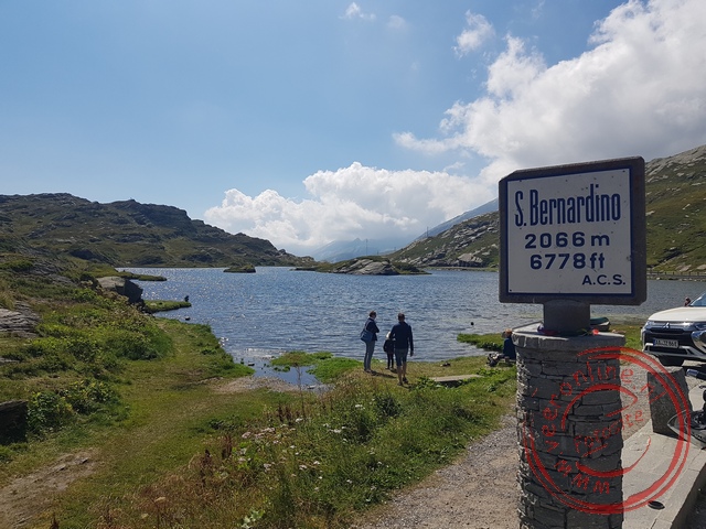
Dozens of cars are parked. We step out for a moment to look over the lake. It is far too busy here for our picnic lunch. We drive a little further. On a narrow parking strip, we park the car. Here we are alone. We unfold the chairs and enjoy the beautiful view during lunch. After lunch, we descend the mountain pass on the other side. The signs here are in Italian. This is the Italian-speaking part of Switzerland. We are also not far from the Italian border. The descent is several kilometers long. For a long time, we don’t need to accelerate, only brake occasionally for the bends. In the valley, we turn towards the Gotthard Pass. Here too, we have the choice between the pass and the tunnel. We choose the mountain pass again. Just before the pass, there is a traffic jam. There is a police check. It seems the police are checking every car one by one. An officer gestures for us to continue. What might they be looking for? The road quickly climbs again. At a viewpoint just below the top, we stop. From here, we can see the old Gotthard mountain pass. Next to the road we took up, the old route winds with even sharper bends. From above, we see the road twisting down the valley. This route seems popular with cyclists and motorcyclists. We unfold our chairs again and enjoy the view. We don’t descend via the mountain pass we just viewed. The descent to Lucerne lies on the north side. Via a relatively gentle descent, we drive to Lucerne. Around half past four, we arrive at the parking lot of the Ibis hotel in the city center. Exactly one spot is still free. We quickly park our car. The room is not very large but sufficient for sleeping. From the hotel, we can walk to the center.

It is still nice weather when we reach the bank of the Reuss River at the Chapel Bridge. This old wooden covered bridge is the oldest crossing between the two parts of the city. The first version of the wooden bridge was built in the 14th century. We walk over the 200-meter-long bridge. On the other side of the river lies the old town. Narrow streets and decorated houses form the streetscape. What a charming city! At one of the squares, we order something to drink. It looks cozy enough to have dinner as well.
 Switzerland
  The bridges and viaducts in the Swiss landscape
 Zermatt is a typical winter sports village
 The 200meterlong Chapel Bridge in Lucerne
 The village of Zermatt between the mountains
Travelogue Road Trip Germany and Switzerland
Dag 2 | Germany > Medieval Rothenburg
Dag 3 | Germany > Harburg and Ottobeuren
Dag 4 | Switzerland > The St. Gallen Library
Dag 5 | Liechtenstein > Fürstensteig Mountain Hike
Dag 6 | Switzerland > Around the Davos Lake
Dag 7 | Switzerland > Through the Mountains to Lucerne
Dag 8 | Switzerland > The Dying Lion
Dag 9 | Switzerland > The Oeschinen Mountain Lake
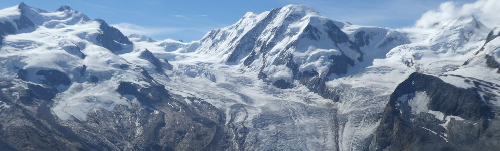
Dag 10 | Switzerland > On Top of the Gornergrat
Dag 11 | Switzerland > The Great St. Bernard Pass
Dag 12 | Switzerland > The Castle of Chillon
Dag 13 | Germany > The Basel Minster
Dag 14 | Germany > The Cologne Cathedral
Dag 15 | Germany > Historic Monschau
Dag 16 | Germany > Farewell Monschau