154 countries
(and areas)
 - Azerbaijan
- Bahrain
- Barbados
- Belgium
- Belize
- Benin
- Bhutan
- Bolivia
- Bonaire
- Bosnia and Herzegovina
- Botswana
- Brazil
- British Virgin Islands
- Brunei
- Bulgaria
- Cambodia
- Canada
- Cape Verde
- Chile
- China
- Costa Rica
- Croatia
- Cuba
- Curacao
- Cyprus
- Czech Republic
- Denmark
- Dominica
- Dominican Republic
- Egypt
- El Salvador
- England
- Estonia
- Eswatini (Swaziland)
- Ethiopia
- Fiji
- Finland
- France
- French Guiana
- Georgia
- Germany
- Gibraltar
- Greece
- Grenada
- Guadeloupe
- Guatemala
- Honduras
- Hong Kong
- Hungary
- Iceland
- India
- Indonesia
- Iran
- Ireland
- Israel
- Italy
- Jamaica
- Japan
- Jordan
- Kazakhstan
- Kenya
- Kosovo
- Kuwait
- Kyrgyzstan
- Laos
- Latvia
- Lebanon
- Lesotho
- Liechtenstein
- Lithuania
- Luxembourg
- Macau
- Madagascar
- Malawi
- Malaysia
- Maldives
- Malta
- Martinique
- Mexico
- Moldova
- Monaco
- Mongolia
- Montenegro
- Morocco
- Mozambique
- Namibia
- Nepal
- Netherlands
- New Zealand
- Nicaragua
- North Macedonia
- Northern Ireland
- Norway
- Oman
- Pakistan
- Palestine
- Peru
- Philippines
- Poland
- Portugal
- Qatar
- Republic of Korea
- Romania
- Russia
- Saint Kitts and Nevis
- Saint Lucia
- Saint Martin
- Saint Vincent and the Grenadines
- San Marino
- São Tomé and Principe
- Saudi Arabia
- Scotland
- Senegal
- Serbia
- Singapore
- Sint Maarten
- Slovakia
- Slovenia
- South Africa
- Spain
- Sri Lanka
- Suriname
- Sweden
- Switzerland
- Tajikistan
- Tanzania
- Thailand
- The Gambia
- Tibet
- Togo
- Transnistria
- Trinidad and Tobago
- Tunisia
- Turkey
- Turkmenistan
- Uganda
- United Arab Emirates
- United States
- Uruguay
- Uzbekistan
- Vatican City
- Vietnam
- Wales
- Zambia
- Zanzibar
- Azerbaijan
- Bahrain
- Barbados
- Belgium
- Belize
- Benin
- Bhutan
- Bolivia
- Bonaire
- Bosnia and Herzegovina
- Botswana
- Brazil
- British Virgin Islands
- Brunei
- Bulgaria
- Cambodia
- Canada
- Cape Verde
- Chile
- China
- Costa Rica
- Croatia
- Cuba
- Curacao
- Cyprus
- Czech Republic
- Denmark
- Dominica
- Dominican Republic
- Egypt
- El Salvador
- England
- Estonia
- Eswatini (Swaziland)
- Ethiopia
- Fiji
- Finland
- France
- French Guiana
- Georgia
- Germany
- Gibraltar
- Greece
- Grenada
- Guadeloupe
- Guatemala
- Honduras
- Hong Kong
- Hungary
- Iceland
- India
- Indonesia
- Iran
- Ireland
- Israel
- Italy
- Jamaica
- Japan
- Jordan
- Kazakhstan
- Kenya
- Kosovo
- Kuwait
- Kyrgyzstan
- Laos
- Latvia
- Lebanon
- Lesotho
- Liechtenstein
- Lithuania
- Luxembourg
- Macau
- Madagascar
- Malawi
- Malaysia
- Maldives
- Malta
- Martinique
- Mexico
- Moldova
- Monaco
- Mongolia
- Montenegro
- Morocco
- Mozambique
- Namibia
- Nepal
- Netherlands
- New Zealand
- Nicaragua
- North Macedonia
- Northern Ireland
- Norway
- Oman
- Pakistan
- Palestine
- Peru
- Philippines
- Poland
- Portugal
- Qatar
- Republic of Korea
- Romania
- Russia
- Saint Kitts and Nevis
- Saint Lucia
- Saint Martin
- Saint Vincent and the Grenadines
- San Marino
- São Tomé and Principe
- Saudi Arabia
- Scotland
- Senegal
- Serbia
- Singapore
- Sint Maarten
- Slovakia
- Slovenia
- South Africa
- Spain
- Sri Lanka
- Suriname
- Sweden
- Switzerland
- Tajikistan
- Tanzania
- Thailand
- The Gambia
- Tibet
- Togo
- Transnistria
- Trinidad and Tobago
- Tunisia
- Turkey
- Turkmenistan
- Uganda
- United Arab Emirates
- United States
- Uruguay
- Uzbekistan
- Vatican City
- Vietnam
- Wales
- Zambia
- Zanzibar


Copyright 2004 - 2026
Veeronline.nl Travel Adventures

Home > New Zealand > Fiji and New Zealand > Travelogue day 30
Travelogue Fiji and New Zealand
December 28 2018 February 2 2019 (39 days)
New Zealand > Boat trip Milford Sound
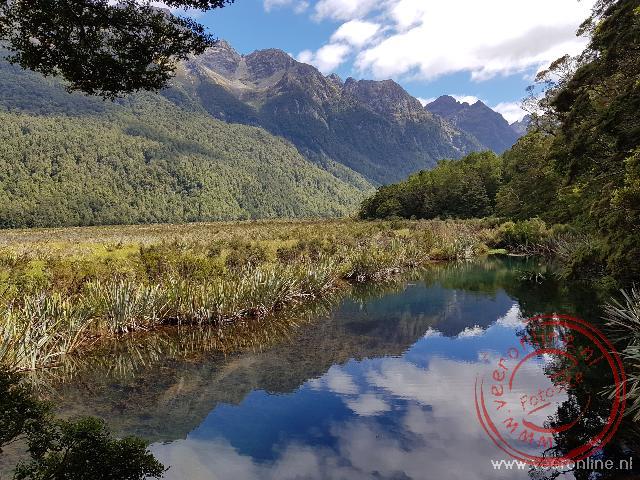
Dag 30 - Thursday, January 24, 2019It’s still dark outside when the alarm goes off. It’s half past five. We shower and have breakfast in our cottage. Just before half past six, we set off. The boat in Milford Sound departs at nine o’clock. The distance to Milford Sound is 120 kilometers, and it’s advised to allow at least two hours for the drive. The road is quiet, and the weather looks beautiful. The mountain peaks are already illuminated by the first rays of the sun. A morning mist hangs over the lake, obscuring our view at Mirror Lake. Normally, you can see the reflection of the mountains in the water here. We’ll probably have a better view on the way back. The road winds through the mountains, and the views get increasingly spectacular. At the tunnel through the mountain, traffic is controlled by a traffic light. Vehicles take turns passing through the 1,200-meter-long tunnel. The Keas, a type of mountain parrot, know this all too well.

These cheeky birds approach the cars looking for food. One bird perches on a car and taps on the windshield for attention. Signs warn everywhere not to feed them, as it reinforces this behavior. The light turns green, and we pass through the tunnel. Construction on the tunnel began in 1934 as an employment project and took a full twenty years to complete. On the other side of the narrow tunnel, we enter Milford Sound. Through hairpin bends, we descend to the harbor. Several boats are ready to go—probably every tourist on the South Island takes this excursion. When we board, it’s immediately noticeable how chilly it is in the shadow of the mountains. The temperature is around five degrees Celsius. Milford Sound is the most beautiful fjord in Fiordland. The steep cliffs contrast sharply with the blue water. Mitre Peak is the highest and most famous mountain around the fjord. The pyramid-shaped rock rises 1,692 meters above the water. The skipper navigates the boat through the 16-kilometer-long Milford Sound. The boat looks tiny compared to the towering cliffs. Waterfalls cascade down at various points—both large and small. It seems as though streams of water are falling everywhere. The skipper steers the boat right under one of the waterfalls, and the people on the bow are soaked by the spray. At the entrance of Milford Sound, near the sea, the boat turns around. We return via the other side, which also offers beautiful views. The sun shines on the mountain ranges across the fjord, but the boat is now in shadow, and it immediately feels cold. I leave the upper deck and continue enjoying the view from inside. After two hours, we are back at the harbor. What a stunning trip, and what luck that we moved it to today—the weather was perfect. We drive back along Milford Sound Road toward Te Anau. Just before the tunnel is the Chasm Waterfall. A short walk brings us to this 20-meter-high waterfall. From the bridge, we can see the water plunging through a rocky cleft. The road is much busier than this morning, with tour buses shuttling tourists from Queenstown to the sounds. I’m actually surprised at how many tourists are in this area to fill all the boat trips. On the other side of the tunnel, we stop again at Mirror Lake. Now the view is better, and the mountains are reflected in the clear water. We pull over for a sandwich. From Te Anau, the actual journey for today begins.
We are heading to the southernmost tip of the South Island—only Stewart Island lies further south. We choose not to take the main route, as we already drove part of it yesterday. Instead, we take an inland route to the coast at Pahia and then follow the coastline eastward. We drive through beautiful rolling landscapes, passing sheep and deer farms. Unlike the boat trip this morning, it’s cloudy on the south coast, and the wind is strong. Slope Point is officially the southernmost point. From the parking area, it’s a twenty-minute walk to reach the point. Here stands a sign showing the distances to the Equator and Antarctica. You have to be careful not to be blown over by the strong wind. A few kilometers further is Curio Bay, where the rare yellow-eyed penguins sometimes come ashore. Dolphins are also occasionally spotted in the bay. No matter how we look, we don’t see any penguins. We do catch a glimpse of the petrified trees on the beach, which are 70 million years old. Outside of backpackers at the campsite, the Curio Bay area doesn’t appear to attract many tourists. The village has only a handful of houses. We spend the night in Waitaka, the next village. Upon arrival, Waitaka seems no larger than Curio Bay—just a church, a museum, a few houses, and a takeaway café. Our accommodation must be somewhere here—but where? From the takeaway, we are directed to the adjacent house. Hesitantly, we go inside. There are other guests as well, and a note indicates that we have room two. The cottage has a living room with three bedrooms and shared bathrooms. In the garden, there is an additional building with four single beds. An English couple warns us that the takeaway closes at seven, so we quickly order fish and chips from the converted caravan—nothing else is available nearby. In the evening, we return to Curio Bay.
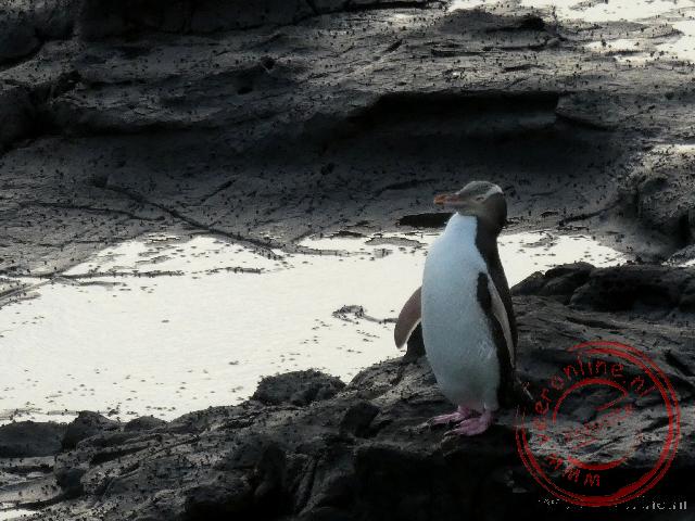
Penguins usually appear in the evening. The beach is now considerably busier, with several people standing with cameras. One yellow-eyed penguin is on the beach—a delightful sight to see this rare bird. For safety, volunteers have strung a rope that everyone must stay behind, giving the penguin at least fifty meters of freedom. On the other side, we also check Porpoise Bay, where the equally rare blue penguin sometimes comes ashore and dolphins are occasionally seen. Tonight, the bay is empty.
 Fiji
Fiji  The beach at the resort
 New Zealand
  The unique surroundings of WaiOTapu
 Crew members playing music on board the sailing ship
 A seagull on the statue of Abel Tasman
Travelogue Fiji and New Zealand
Dag 2 | Fiji > The airport of Guangzhou
Dag 3 | Fiji > The hotel is closed
Dag 4 | Fiji > Shopping in Sigatoka
Dag 5 | Fiji > The Viti Levu highlands
Dag 6 | Fiji > New Year's Eve in Fiji
Dag 7 | Fiji > Deep sea fishing
Dag 8 | New Zealand > To New Zealand
Dag 9 | New Zealand > The apartment is already occupied
Dag 10 | New Zealand > Dolphin spotting
Dag 11 | New Zealand > To Cape Reinga
Dag 12 | New Zealand > The Cathedral Cove
Dag 13 | New Zealand > Coromandel Coastal Walkway
Dag 14 | New Zealand > Hot Water Beach
Dag 15 | New Zealand > White Island Volcano
Dag 16 | New Zealand > Thermal park Wai-O-Tapu
Dag 17 | New Zealand > Tongariro Alpine Crossing
Dag 18 | New Zealand > To Wellington
Dag 19 | New Zealand > The Te Papa museum
Dag 20 | New Zealand > Ferry to South Island
Dag 21 | New Zealand > No whale watching trip
Dag 22 | New Zealand > The Marlborough Sounds
Dag 23 | New Zealand > Abel Tasman in Nelson
Dag 24 | New Zealand > Kayaking in Abel Tasman N.P.
Dag 25 | New Zealand > To the Pancake Rocks
Dag 26 | New Zealand > Can we go on the glacier?
Dag 27 | New Zealand > To Queenstown
Dag 28 | New Zealand > Funyak on the Dart River
Dag 29 | New Zealand > Te Anau in Fjordland
Dag 30 | New Zealand > Boat trip Milford Sound
Dag 31 | New Zealand > Waterfalls in the Catlins
Dag 32 | New Zealand > To Dunedin
Dag 33 | New Zealand > Otago Peninsula
Dag 34 | New Zealand > Moeraki Boulders
Dag 35 | New Zealand > Helicopter hike on the glacier
Dag 36 | New Zealand > Lake Tekapo
Dag 37 | New Zealand > Christchurch after the earthquake
Dag 38 | New Zealand > Departure Auckland
Dag 39 | New Zealand > From China to Home