153 countries
(and areas)
 - Azerbaijan
- Bahrain
- Barbados
- Belgium
- Belize
- Benin
- Bhutan
- Bolivia
- Bonaire
- Bosnia and Herzegovina
- Botswana
- Brazil
- British Virgin Islands
- Brunei
- Bulgaria
- Cambodia
- Canada
- Cape Verde
- Chile
- China
- Costa Rica
- Croatia
- Cuba
- Curacao
- Cyprus
- Czech Republic
- Denmark
- Dominica
- Dominican Republic
- Egypt
- El Salvador
- England
- Estonia
- Eswatini (Swaziland)
- Ethiopia
- Fiji
- Finland
- France
- French Guiana
- Georgia
- Germany
- Gibraltar
- Greece
- Grenada
- Guadeloupe
- Guatemala
- Honduras
- Hong Kong
- Hungary
- Iceland
- India
- Indonesia
- Iran
- Ireland
- Israel
- Italy
- Jamaica
- Japan
- Jordan
- Kazakhstan
- Kenya
- Kosovo
- Kuwait
- Kyrgyzstan
- Laos
- Latvia
- Lebanon
- Lesotho
- Liechtenstein
- Lithuania
- Luxembourg
- Macau
- Madagascar
- Malawi
- Malaysia
- Maldives
- Malta
- Martinique
- Mexico
- Moldova
- Monaco
- Mongolia
- Montenegro
- Morocco
- Mozambique
- Namibia
- Nepal
- Netherlands
- New Zealand
- Nicaragua
- North Macedonia
- Northern Ireland
- Norway
- Oman
- Pakistan
- Palestine
- Peru
- Philippines
- Poland
- Portugal
- Qatar
- Republic of Korea
- Romania
- Russia
- Saint Kitts and Nevis
- Saint Lucia
- Saint Martin
- Saint Vincent and the Grenadines
- San Marino
- Saudi Arabia
- Scotland
- Senegal
- Serbia
- Singapore
- Sint Maarten
- Slovakia
- Slovenia
- South Africa
- Spain
- Sri Lanka
- Suriname
- Sweden
- Switzerland
- Tajikistan
- Tanzania
- Thailand
- The Gambia
- Tibet
- Togo
- Transnistria
- Trinidad and Tobago
- Tunisia
- Turkey
- Turkmenistan
- Uganda
- United Arab Emirates
- United States
- Uruguay
- Uzbekistan
- Vatican City
- Vietnam
- Wales
- Zambia
- Zanzibar
- Azerbaijan
- Bahrain
- Barbados
- Belgium
- Belize
- Benin
- Bhutan
- Bolivia
- Bonaire
- Bosnia and Herzegovina
- Botswana
- Brazil
- British Virgin Islands
- Brunei
- Bulgaria
- Cambodia
- Canada
- Cape Verde
- Chile
- China
- Costa Rica
- Croatia
- Cuba
- Curacao
- Cyprus
- Czech Republic
- Denmark
- Dominica
- Dominican Republic
- Egypt
- El Salvador
- England
- Estonia
- Eswatini (Swaziland)
- Ethiopia
- Fiji
- Finland
- France
- French Guiana
- Georgia
- Germany
- Gibraltar
- Greece
- Grenada
- Guadeloupe
- Guatemala
- Honduras
- Hong Kong
- Hungary
- Iceland
- India
- Indonesia
- Iran
- Ireland
- Israel
- Italy
- Jamaica
- Japan
- Jordan
- Kazakhstan
- Kenya
- Kosovo
- Kuwait
- Kyrgyzstan
- Laos
- Latvia
- Lebanon
- Lesotho
- Liechtenstein
- Lithuania
- Luxembourg
- Macau
- Madagascar
- Malawi
- Malaysia
- Maldives
- Malta
- Martinique
- Mexico
- Moldova
- Monaco
- Mongolia
- Montenegro
- Morocco
- Mozambique
- Namibia
- Nepal
- Netherlands
- New Zealand
- Nicaragua
- North Macedonia
- Northern Ireland
- Norway
- Oman
- Pakistan
- Palestine
- Peru
- Philippines
- Poland
- Portugal
- Qatar
- Republic of Korea
- Romania
- Russia
- Saint Kitts and Nevis
- Saint Lucia
- Saint Martin
- Saint Vincent and the Grenadines
- San Marino
- Saudi Arabia
- Scotland
- Senegal
- Serbia
- Singapore
- Sint Maarten
- Slovakia
- Slovenia
- South Africa
- Spain
- Sri Lanka
- Suriname
- Sweden
- Switzerland
- Tajikistan
- Tanzania
- Thailand
- The Gambia
- Tibet
- Togo
- Transnistria
- Trinidad and Tobago
- Tunisia
- Turkey
- Turkmenistan
- Uganda
- United Arab Emirates
- United States
- Uruguay
- Uzbekistan
- Vatican City
- Vietnam
- Wales
- Zambia
- Zanzibar


Copyright 2004 - 2026
Veeronline.nl Travel Adventures

Home > New Zealand > Fiji and New Zealand > Travelogue day 35
Travelogue Fiji and New Zealand
December 28 2018 February 2 2019 (39 days)
New Zealand > Helicopter hike on the glacier
Dag 35 - Tuesday, January 29, 2019An exciting day today. Would the glacier tour go ahead? When we wake up, it’s cloudy. Yesterday the weather forecast had looked better. We can call at nine o’clock to check if the helicopter flight will take place. Just to be safe, we decide not to go on a mountain hike in the morning. If the tour doesn’t go ahead, we can still head into the mountains later. The nine o’clock call gives only a partial answer. They will be flying this morning. That’s good news, but just to be sure we need to call again around twelve. The weather in the mountains can change quickly. We feel confident. We drive along Lake Pukaki again towards Mount Cook Village, this time taking the Tasman Valley. From the parking lot, the viewpoint over the Tasman Glacier meltwater stream is easily accessible. On the other side of the lake lies the Tasman Glacier. The ice mass flows into the lake. The entire underside of the glacier is covered with debris, stones, and boulders, giving it a black color instead of white from the snow. How different the higher glaciers on the Mount Cook slopes look—the blue of the glacier ice is clearly visible. Large ice blocks float in the lake, broken off from the glacier. Once the ice melts, it flows via the Tasman River into Lake Pukaki. Since we’re close to the airport, we decide not to call but drive directly to the location. There comes the long-awaited confirmation: it’s happening! At the small airport building, we are fitted with crampons for our shoes. The process is slow. The Chinese children, in particular, don’t understand the instructions. Fortunately, a couple from Taiwan translates for them. Eventually, everyone has their gear and safety instructions. The group consists of 22 people, divided into four colors. The two helicopters first take the first two groups to the glacier. They walk there with one guide. Once the helicopters return, we follow in the second shift with a second guide. When the helicopter lands, I walk cautiously toward it. The rotors are still spinning.

Six passengers can fit—smaller passengers sit in the front. We take the back seats. Immediately after the door closes, the helicopter lifts off. We fly toward the mountains. Only when we approach the ridge do we realize how enormous the peaks are. The helicopter seems tiny in comparison. Below, I can see the Tasman Glacier Lake. I recognize the spots where I walked this morning. We approach the glacier itself. The further we go, the more the glacier shifts between black from rock debris and white from snow. We land somewhere in between.

I step out carefully. Everyone must duck when the pilot lifts off again. A strong gust of wind sweeps over me. The second helicopter follows. Chris is the guide on the glacier and welcomes me. I strap on my crampons. “Be careful,” Chris warns. While walking, you can hit your other foot with the metal points. He also cautions that you need to lift your feet higher. If you fall, the sharp ice can hurt badly. We set off. I follow Chris across the glacier. What a stunning environment. Water flows everywhere through the ice—sometimes a small trickle, sometimes a full stream. There are also treacherous holes in the ice, some filled with water, others meters deep. Walking on a glacier is not without danger, Chris explains. The glacier moves fifty centimeters per day, which means the ice conditions change daily. Where I stand, the ice mass is 400 meters thick—almost unimaginable. Chris continues: the Tasman Glacier, at 24 kilometers, is one of the longest glaciers.
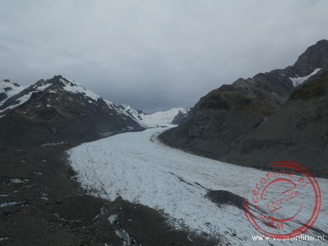
It used to reach all the way to Mount Cook Village, but since the 1970s a lake has formed at the glacier’s base. The water in the lake accelerates the melting process. The glacier is expected to retreat several more kilometers before stabilizing. Chris gestures for us to follow. He enters a narrow crevice that opens into a tunnel. I walk under the glacier ice. The intense blue of the compressed ice is clearly visible here. The tunnel opens into a hollow chamber, where everything also glows blue. How beautiful this is. Through another passage, I follow Chris back to the exit. I estimate I walked about fifty meters beneath the ice. At the ice cave exit, there is a second opening over three meters wide. It’s remarkable that such passages form under the ice. Back on the glacier, we walk toward the whiter ice section. The layer of stones helps cool it, slowing the melt. This layer forms because New Zealand’s mountain range is mostly made of brittle rock. Other mountain ranges around the world have much harder rock. Loose debris easily breaks off and falls onto the ice. After two hours exploring this extraordinary place, it’s time to be picked up by the helicopter. The pilot flies a loop over the glacier. From the air, the massive snow and ice fields on the surrounding mountains are clearly visible. What seemed only a few meters thick from the ground is actually forty to fifty meters thick. The helicopter next to us suddenly looks tiny. We safely return to Mount Cook Airport. Full of this incredible experience, we drive back to Twizel.
 New Zealand
  The lively harbour of Auckland
 The Sky Tower is the tallest building in New Zealand
 Fiji
Fiji  The fish arent biting but the waves are getting stronger
 New Zealand
  The path of the Sealy Tarns Track
Travelogue Fiji and New Zealand
Dag 2 | Fiji > The airport of Guangzhou
Dag 3 | Fiji > The hotel is closed
Dag 4 | Fiji > Shopping in Sigatoka
Dag 5 | Fiji > The Viti Levu highlands
Dag 6 | Fiji > New Year's Eve in Fiji
Dag 7 | Fiji > Deep sea fishing
Dag 8 | New Zealand > To New Zealand
Dag 9 | New Zealand > The apartment is already occupied
Dag 10 | New Zealand > Dolphin spotting
Dag 11 | New Zealand > To Cape Reinga
Dag 12 | New Zealand > The Cathedral Cove
Dag 13 | New Zealand > Coromandel Coastal Walkway
Dag 14 | New Zealand > Hot Water Beach
Dag 15 | New Zealand > White Island Volcano
Dag 16 | New Zealand > Thermal park Wai-O-Tapu
Dag 17 | New Zealand > Tongariro Alpine Crossing
Dag 18 | New Zealand > To Wellington
Dag 19 | New Zealand > The Te Papa museum
Dag 20 | New Zealand > Ferry to South Island
Dag 21 | New Zealand > No whale watching trip
Dag 22 | New Zealand > The Marlborough Sounds
Dag 23 | New Zealand > Abel Tasman in Nelson
Dag 24 | New Zealand > Kayaking in Abel Tasman N.P.
Dag 25 | New Zealand > To the Pancake Rocks
Dag 26 | New Zealand > Can we go on the glacier?
Dag 27 | New Zealand > To Queenstown
Dag 28 | New Zealand > Funyak on the Dart River
Dag 29 | New Zealand > Te Anau in Fjordland
Dag 30 | New Zealand > Boat trip Milford Sound
Dag 31 | New Zealand > Waterfalls in the Catlins
Dag 32 | New Zealand > To Dunedin
Dag 33 | New Zealand > Otago Peninsula
Dag 34 | New Zealand > Moeraki Boulders
Dag 35 | New Zealand > Helicopter hike on the glacier
Dag 36 | New Zealand > Lake Tekapo
Dag 37 | New Zealand > Christchurch after the earthquake
Dag 38 | New Zealand > Departure Auckland
Dag 39 | New Zealand > From China to Home